Friday, 10 May 2024

Lucas, Brothers- making bricks at Crayford 1864?

 The Commission on Childrens Employment investigated the brickyards of Crayford in 1864-1865. A major report was presented to Parliament in 1866.  Two Crayford brickyards were reported on: D & C Rutter, and Lucas, Brothers. D & C Rutter were a well known enterprise and traces of their Crayford activities remain. Rutter's pit is marked on the Kennard map of the Crayford brickearths.

Lucas, Brothers presents problems. It is difficult to find traces of their activities in Crayford. Its hard to believe that the Commissioners misplaced the Lucas, Brothers operation but they do not appear in the Crayford section of Kellys Directory of Kent 1862. The 1866 Report of the Commissioners has a substantial section on Lucas,Brothers:

Reports from Commissions v.24

Crayford Messrs Lucas, Brothers.  In the summer of 1864 there were 112 persons employed here; one girl and three boys under 13 years old; six girls and eleven boys between 13 and 18; and six females over 18. Mr H.W.Lord reports.

Mr.Nevill (manager?) reports- The children are employed at the stools with the brick moulders, they are frequently the children of the moulder or some other person in the gang but not always so. We have 52(maybe 32 - report indistinct at this point) stools; there are usually seven persons to each; the children are either barrow loaders or pug boys; the pug boy carries the clay in his arms from the pug mill to the moulder; sometimes a man has two small pug boys of ten tears old or so, instead of one older one; one of these two cuts the clay as it comes from the bottom of the pug mill with a kind of flat fork, which they call a 'cackle'; the barrow loader is often a girl . The clay is prepared for the moulder by a 'walk flatter', who stands by the moulders side, and receives the clay from the pug boy; that is often done by women. The bricks weigh 8 lbs each, there are 28 bricks loaded on each barrow before it is wheeled off; the 'pushers-on' (that is those who wheel off) are usually men. 

Mr.Lord reports' I went with Mr Nevill to every stool in both the brickfields worked by Messrs Lucas'.  So- two brickfields but where and which? And what do we know about Lucas Brothers?  A Construction company; founded in 1842, defunct in 1895.  Built Albert Hall (1871) Covent Garden Opera House (1858) Charing Cross Station (1864) Cliveden (1851), Charterhouse School, Woolwich Arsenal ? If their brickworks were operating in 1864 it suggests that maybe Craford bricks were used in the construction of Charing Cross Station; not far by barge from Crayford to the Charing Cross site.  But why is there no record of their operations at Crayford?  D & C Rutter- well recorded- no records of Lucas Brothers.


An explanation of the Lucas Bros anomaly:  There was a typographic error in the Commission report and this resulted in the Lucas Bros operation being classified under Crayford rather than Faversham. The Crayford marker in the text was slightly misplaced making Lucas Bros appear in Crayford rather than Faversham; investigations by Mr.J.Howarth of Erith show Lucas Bros listed in the Kellys Directories for 1874 and 1882 and located at Teynham (near Murston, near Sittingbourne, near Faversham). In 1874 near Crayford there were Rutter D & C at Crayford, Furners at Slade Green, Erith, Dawson at Plumstead Common & Wickham Lane, White John Bazley Bros at Swanscombe, Dartford, Greenhithe & Erith.


Thursday, 9 May 2024

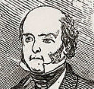
Pictures of Leonard Horner

 There are not many pictures of Leonard Horner around- he was famous but not particularly famous. He was one of the few people mentioned by name by Karl Marx in 'Das Kapital'- for his work trying to improve conditions of working children in Victorian Britain.  His great love was geology, and his best moments were the few years he spent in and around Bonn, in 1831-1833. While the Horner family were in Bonn they were visited by Charles Lyell, who came to see the remarkable geology- and to marry the oldest Horner daughter Mary.  Horner & Lyell explored the crater of the Rodderberg, and examined the loess that it contained.

Horner presented a paper on 'The Geology of Bonn' to the Geological Society in London in 1833- it was published in 1836. One of the first papers on loess in English; a useful complement to Lyell's 1834 Edinburgh paper.  For more about Horner and loess read Smalley (2020) and/or Smalley & Markovic (2018).

Smalley, I.J.  2020.  Leonard Horner in Bonn 1831-1833, finding loess and being incorporated into Lyell's Loess Legion.  GeoLogos 26, 163-170.

Smalley, I.J., Markovic, S.B.  2018.  An enthusiasm for loess: Leonard Horner in Bonn and Liu Tung-sheng in Beijing.  Open Geosciences 10, 925-931. 

Loess200*2024


Wednesday, 1 May 2024

North End 1897 Brickearth Country

 This is North End Erith 1897; brickearth workings. Two brickworks in action here; this is 1897 so the pug mills are connected to engine houses. Tracks are visible to move brickearth from the excavation face to the vicinity of the pug mill. There are connections to the Crayford-Erith road which would allow access to Erith dockside.

 North End Erith 1897 Map


Tuesday, 19 March 2024

"Thames reds" have given place to "Flettons"

 There was a modest loess fall over south-eastern England in around 20,000 BP. Thats a very rough date, and there were in fact two loess falls, with a short interval in-between, which had some effect on geomorphology and life in southern England. Loess provides agricultural enhancement so farming improved over a substantial area, an admixture is almost as good as a large loess-fall.  This loess would provide material for the making of bricks and for most of the nineteenth century (particularly the early parts) it provided material for the bricks to build London. Many brickpits were opened, mostly small scale enterprises but some large and very productive such as Smeed-Deans at Murston near Faversham. One significant concentration of brick making material was at Crayford in north-west Kent; here the Crayford Brickearths were used, and for many years geologists sought Pleistocene fossils; the brickpits were great sources of material for geologists and collectors.  


Map from Kennard (1944)  pits labelled as W Whites, N Norris, F Furners, R Rutters, S Stoneham


The bricks to make Victorian London have been discussed by Peter Hounsell in his recent book (Bricks of Victorian London. University of Hertfordshire Press Hatfield 283). This is more of a social history than a text on brick manufacture, but Crayford does feature 13 times in the index (on pages 19 30 36 39 68 83 112 132 134 135 159 160 and 161). Most writing about Crayford is by the geologists and palaeontologists; the brick pits were very popular in the nineteenth century and much visited by Geologists Association excursions; the opening of Slades Green station on the South Eastern Railway in 1900 facilitated latter day visiting; the station opened as Slades Green but the name was changed to Slade Green in 1953.

The Benchmark paper on the Crayford Brickearths is Kennard (1944)- this discussion largely revolves around this paper. The title quotation comes from here (p.122).

"Thames reds" have given place to "Flettons"   Kennard demarcates the ending of brick production in Crayford and the overwhelming arrival of the Fletton machine-made bricks. Kennard collected at Crayford between 1892 and 1900 and observed the decline of the industry. 

Alfred Santer Kennard 1944. The Crayford Brickearths.  Proceedings of the Geologists Association 55, 121-167. The definitive map is by Kennard- see above, related to relevant OS map.

That short quote is critical. Most of the paper is given up to fossil collecting and Pleistocene geology; there is a small part on actual bricks and brickpit geography. The quote suggests that Crayford was producing bricks that fired to red-the Thames Reds, which must mean that no chalk admixtures were used, and perhaps no spanish. There appears to be no records of spanish being used in the Crayford bricks. The great source of brickearth bricks was further down the river, at Smeed Dean at Murston. These bricks fired to yellow- the famous yellow of the London Stock brick. The yellow colour was obtained by adding chalk; the other key admixture was the so-called 'spanish' which was a mixture of cinders and ashes from London's rubbish. This made firing more economic by providing an internal fuel source. As Nature obligingly did with the Flettons, from the midland clays.

..full accounts of the deposits have been given by Morris[1], Dawkins[12], Tylor[19], Whitaker[44}, Chandler & Leach[69,77,79]

1.   Morris, J. 1838.  On the deposits containing Carnivora and other Mammalia in the Valley of the Thames.  Ann.Mag.Nat.Hist. series II, vol.2, 539-548. An excellent account of the deposits, with four sections.. Though said to be at Erith one section is clearly that at Stoneham's pit, Crayford..

12.  Dawkins, W.B.  1867.  On the age of the Lower Brickearths of the Thames Valley.  Quart.J. Geol.Soc. London 23, 91-109.

19.  Tylor, A.  1869.  On Quaternary gravels.  Quart.J. Geol. Soc. London 25, 57-100.  There are five carefully measured sections of Erith, and eight of Stoneham's pit.

44.  Whitaker, W.  1889.  The Geology of London.  Mem. Geol. Survey 1, 328-478.  By far the best summary. This volume has been reprinted by Forgotten Books as a pod book. Picture of WW below.

69.  Leach, A.L.  1905.  Excursion to Erith and Crayford.  Proc. Geol. Assoc. 19, 137-141.

77.  Chandler, R.H., Leach, A.L. 1912.  Report of an excursion.. Pleistocene river drifts near Erith. Proc.Geol. Assoc. 23, 183-190. 

79.  Chandler, R.H.  1914.  The Pleistocene deposits of Crayford.  Proc.Geol. Assoc. 25, 61-71.


Whitaker, W.  1889.   The Geology of London and of parts of the Thames Valley (Explanation of Sheets 1, 2 and 7). Memoirs of the Geological Survey of England and Wales. HMSO London 556p. POD book by Forgotten Books; copy from Harvard University

p.432.  Prof. Morris seems..  to have been the first to describe the great sections of Erith and Crayford..    Unfortunately, of the four sections described in this paper, the precise locality of only one, near Crayford [Stonehams] is given; though presumably the others follow on in order, northward, to Erith.

p.436.  At Northend, on the southern side of Colyers Lane, a new pit has been opened [Norris pit] since the six inch ordnance map was made, a little south of the Erith pit, and just NW of the Happy Home Inn. It was carried down to a depth of from 35 to 40 feet (in 1887), being deepest on the west. 

p.439.  When I last saw the Crayford section [Stonehams], in the summer of 1888, the northern part had been cut back much further, even to touching the road [Howbury Lane-near Slade Green], by Manor Farm.

Wednesday, 14 June 2023

Loess Words- A Glössary

 Words associated with Loess; words belonging to the world of Loess; words that need explaining- and could benefit from some discussion; words that might be deployed more widely. 


Loessification  L.S.Berg 1964  Loess as a Product of Weathering and Soil Formation.  Israel Program for Scientific Translations Jerusalem 207p translated from the Russian by A.Gourevitch. This is now the basic Berg reference; most of his work was published in Russian and is now hard to find. The 1964 book is translation of material from 1947; from Berg 1964 p.20:

"The difference between loess and its parent rock is like the distinction between soil and rock: the transformation of the latter into the former requires a soil-forming process; in the same manner, the transformation of rock into a loess requires a loess-forming process. The process, though variable in each instance, is everywhere the same in its principle; it is a 'loessification' ; and from this standpoint we are justified in assuming a single family of loessic rocks."

Collapsibility

Chernozemisation

Adobe

Brickearth   

Silt

Dictionaries.  Heinemann New Zealand Dictionary 1979:  loess (say lerss)  noun; a loose, usually yellowish, deposit of wind-blown soil, particularly common in China. (German)

Cavitation

Suspension

Verbreitung

Comminution

Heneberg compromise

Flow-stick transition


Schneckenhausel Boden  Sam.Hibbert, in 1832, wrote about the naming of Loess..  "It has been described under various names, of which the most adopted is that of Loess. According to M.Von Leonhard, its synonyms, as they occur along the course of the Rhine, are Loesch, Schneckenhausel-Boden, Mergel, (in the upper lands of Boden,) and Briz."

Mergel

Briz

Parna

Mercia Mudstone

Windy Day

Loess Commission INQUA    The Loess Commission was founded by Julius Fink (a professor in Wien in Austria) he founded it initially as a sub-commission of the Stratigraphy Commission of INQUA (Internationale Quartarvereinigung)[for data on INQUA see Loess Letter 65]- at the 1961 meeting of INQUA in Poland; at the Paris INQUA Congress of 1969 it was upgraded to full commission status; Fink stayed as President. He handed over to Marton Pecsi of the Hungarian Academy of Sciences in 1977 at the UK Congress.

Hydroconsolidation


Zingg shapes.  "By considering the ellipsoid, Smalley's modified Zingg classes are given as I a = b >c disc, II a = b =c sphere; III a >b >c blade and IV a >b= c rod. The classical Zingg approach and Smalley's approach can be unified if an internal parameter 0<=p<= 1 is introduced, the classical Zingg system corresponds to p = 2/3, Smalley's suggestion corresponds to p = 1." [Domokos et al. Math. Geosci. 42, 29-47, 2010 ]. doi 10.1007/5 11004-009-9250-4 

Black Soils:  The great black soils of Ukraine and the Mid West, what the Russians called Chernozems, were loess before they were chernozems; now they are chernozems developed on loess. A chernozemisation process has operated, post deposition, which has changed the material.. Clay and organic material has accumulated, carbonates have moved.

Mammoths:  R.Dale Guthrie 2001.  Origin and causes of the mammoth steppe: a story of cloud cover, woolly mammoth tooth pits, buckles and inside-out Beringia.  Quaternary Science Reviews 20, 549-574.
"..during the last full glacial (LGM) say 18000 BP most of the north was unimaginably arid.. rivers were reduced to streams...   loess sheets, sand seas, dune fields and wind were common features of this aridity; therefore Pleistocene skies must have been very dusty."


Saturday, 22 April 2023

Ward Chesworth 'Good Soils'

 Ward Chesworth 1982  Late Cenozoic Geology and the Second Oldest Profession.  Geoscience Canada 9(1)  54-61

Geological disturbance leads to good soils (rich in nutrients)-  glaciation leads to loess - and good soils.

Ian Smalley 1984   Good soils and recent geological activity: four maps considered.  New Zealand Soil News  32, 143-146.